National Howl-iday Scene: Part II

Tavish with the holiday lights at the US Botanic Garden

“Season’s Greenings” from the U.S. Botanic Garden! The colorful holiday lights outside merely hint at the wonders that lie within.

Throughout this series, Tavish the Intrepid Pup has been providing an insider’s guide to the national “howl-iday” scene. In his quest to find the most iconic—and dog-friendly—holiday spots the capital region has to offer, Tavish’s “pick of the day” is the annual Season’s Greenings display at the United States Botanic Garden. The institution falls under the auspices of the Architect of the Capitol. Dating to 1850, it has been in its present location on the wedge of land between Maryland Avenue and First Street, S.W., since 1933.

Okay, let’s just start by saying this place is beautiful year-round and is especially so during the holidays. In a city chock-a-block full of monumental and famous structures, it’d be easy to lose this one in the mix. But to do so would be a big mistake. The Botanic Garden takes the lead on horticultural education and issues of sustainable landscape design. With elaborate outdoor terraces and indoor habitats ranging from desert succulents to exotic orchids, there’s something for everyone. Not too be missed is the unique perspective from atop the canopy walk in the tropical rainforest that grows within conservatory’s 93-foot dome. And be sure to check out the magnificent Bartholdi Fountain set upon two acres of rose gardens just across Independence Avenue.
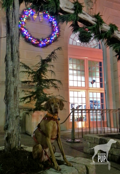
Tavish under the kissing ball at the US Botanic Garden

Will sit for kisses: Tavish has strategically planted himself beneath the mistletoe on the northeast terrace.

Click to see what a "1" on the Wag-a-meter meansDogging the Details

38°53′17.90″N, 77°0′45.46″W
United States Botanic Garden’s “Season’s Greenings”, Washington, DC

Season’s Greenings is on display from late November through early January; check website for exact dates. Admission is free.

Pups aren’t allowed inside the Botanic Garden’s buildings, but fortunately you can lap up pretty good views of Season’s Greenings by peering through the conservatory’s picture windows after dark. One glimpse of the Enchanted Forest in the east gallery is enough to make you want to return on your own to explore inside.
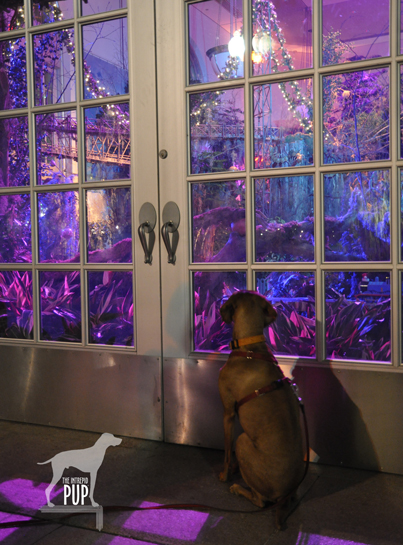
Tavish looking at the train display at the US Botanic Garden

Tavish gazes longingly into the “Enchanted Forest,” just one part of the Season’s Greenings display. Model trains, decorated trees, and fairytale lighting make this a feast for the senses.

Planning for Season’s Greenings takes nearly a year, with the Enchanted Forest alone requiring approximately three weeks to install. It shows in the details. A carpet of poinsettias in 17 varieties. A towering 24-foot tree—one of the largest indoor decorated trees in the region. Eight hundred feet of track for the model railway. A line-up of live music on select evenings. And a mind-boggling assortment of DC landmarks created in miniature and entirely from natural plant materials!

Parking out in front of the Botanic Garden or at meters off Independence Avenue shouldn’t prove too difficult after hours. What’s more, it’s a “two-fer”: soak in the splendor of the lighted gardens and then make the three-minute  stroll across the street to take in the Christmas tree on the west lawn of the U. S. Capitol (read the Intrepid Pup’s earlier account here).

A trip to the grounds of the Botanic Gardens earns a “1″ on the Intrepid Pup’s wag-a-meter as a free and pretty spectacular photo opp for you and your intrepid pup!

Out & About in Vacationland: Part II

Earlier this year Team Tavish wrote about the first Great Maine Outdoor Weekend (GMOW), a new bi-annual event that promotes physical activity and encourages folks to revel in all that’s great about Maine’s natural resources. September 28-30, 2012, marked the second GMOW, and with it, Tavish the Intrepid Pup promised to offer “Part II,” revealing three more stunning destinations in Vacationland. He enjoyed frequenting these places in the 5½ years he lived there, so he’s pretty confident that you and your dog will enjoy them too. So, without further ado…

Dogging the Details

wag-a-meter set at 2

Though in three separate regions of Maine, the excursions described below all rank “2” on the Wag-a-meter as being active, outdoor adventures requiring a little bit of planning. As always, be sure to bring along water for your dog, a snack, and some doggie bags.


MAINE LAKES AND MOUNTAINS

44°56′08.58″ N, 70°32′13.24″ W
Rangeley Lakes, Maine

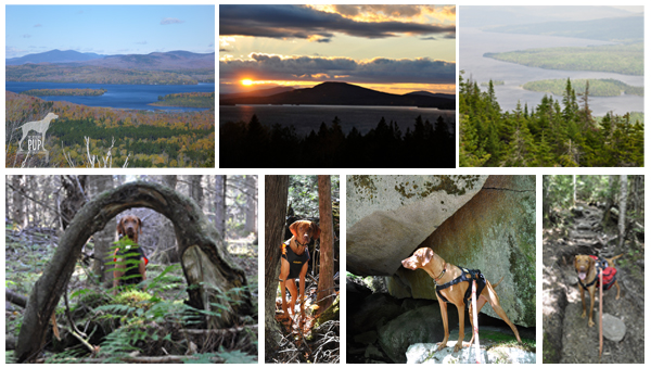
Montage of Rangeley Lakes

Rangeley. The region is virtually synonymous with northern New England, and place names like Mooselookmeguntic and Height of Land simply reinforce its remote and wild allure. It’s the backdrop for Maine’s logging history. The playground for countless generations of sportsmen. The muse of the legendary Carrie Stevens (1882-1970) and her streamer fly. The setting for author Louise Dickinson Rich’s (1903-1991) best sellers, and the thirty-year summer retreat of iconic photographer William Wegman and his famous dogs.

To enter Rangeley is to embrace Maine’s great outdoors. Team Tavish and the Intrepid Pup  have twice stayed at Town & Lake Motel and Cottages; once in late May and again in October. Located on the shore of Rangeley Lake, next to where the sea planes dock, the motel is pet-friendly and a more than adequate home base from which to explore the area. In-room reading is a binder chock full of historical ice out dates, leaving no mistake that this is definitely a place for hard core snowmobilers and ice fishermen.

While Rangeley rightly promotes itself as a four-season wonderland, summer and fall are really the best times for visiting with your dog. Come prepared for great hiking, amazing scenery…and the near certainty of seeing moose.  But be equally prepared for black flies, cool nights, and rapidly changeable weather. Tavish made good use of his Ruffwear™ pack to carry extra food and water for the day. Wearing blaze orange was a must during our autumn hikes as hunting season was in full effect. (Click here to see some of his gear).

The Rangeley Lakes National Scenic Byway is a 35-mile ribbon incorporating sections of Routes 16 and 17. It’s also the access corridor to a number of trail heads of varying lengths and degrees of difficulty.  Tavish-approved highlights include:

  • The short 0.5 mile trail at the 2000-foot Cascade Stream Gorge, with views of 16-foot waterfalls and deep pools.
  • The roadside turnoff at Smalls Falls, with a walkway to see the 54-foot falls.
  • A 1.75 mile trail to the summit of Bald Mountain (2443 feet), with its 30-foot lookout tower.
  • The Appalachian Trail, with a 1.4 mile section to the impressive Piazza Rock.
  • Miles of trails on the 4120-foot Saddleback Mountain. This ski resort permits hikers on base area trails and ski runs during the off season. The chair lifts aren’t operational in the summer, but parts of the main lodge remain open. With wide open spaces, lots of birds to watch, and plenty of evidence of deer and moose, this was probably Tavish’s favorite to explore.


GREATER PORTLAND AND CASCO BAY

43°49′14.47″ N, 70°04′54.05″ W
Wolfe’s Neck Woods State Park, Freeport, Maine

Montage of Wolfe's Neck

Even if you’re otherwise unfamiliar with Maine, you’ve likely heard of Freeport, thanks to it being the venerated home of  outdoor outfitter L.L. Bean. The  flagship store is so touted as a Maine destination that you pretty much have to stop by. While you’re there, sneak a peek at the store’s doors. They’re notable for what’s missing, namely locks.  Since the facility is open 24 hours a day/365 days a year, there’s simply no need for them. That’s what we call a good dose of Yankee practicality. Seriously, check it out…and be sure to snap a photo out front with the 16-foot replica of the hunting boot that launched the company and secured Leon Leonwood Bean’s legacy in the annals of retail history. While your dog can’t accompany you in the store, there’s plenty of dog gear (hunting and otherwise) to be found inside. And you and your dog can always chill in Discovery Park; in the middle of the L.L. Bean retail campus, this compact greenspace doubles as an expo area during Bean’s product demo days and also has a stage on which the company presents its free summer concert series.

But if you can extricate yourself from the constellation of outlet stores downtown, you’ll find that Freeport “beyond the Boot” has a lot to offer in the way of natural splendor. Just a 5-minute drive and you’re quickly away from the 3 million visitors who flock to town each year. Take Bow Street to Flying Point Road, and make Wolfe’s Neck Woods State Park your destination.  L.L. Bean’s Paddling Center is just an inlet away from this easily accessible state park.

While you won’t likely get short of breath walking at Wolfe’s Neck, the views will most certainly take your breath away. Within steps of leaving the parking lot picnic area, the Casco Bay Trail slopes gently to where emerald conifer forest meets azure sea and sky. The stolid outcrops that dot the bay are whimsically called the “Calendar Islands,” because surely there are 365…one for every day of the year! The closest is Googins Island, an osprey sanctuary, and every time we’ve visited during the summer we’ve seen nesting osprey. The trail skirts a pebbly coastline before linking up to the Harraseckett and Hemlock Ridge trails to form about a mile-long loop returning you to the parking lot. Do note that there are no receptacles along the trail, so bag any waste for disposal back at the picnic area.

MAINE BEACHES

43°14′42.43″ N,  70°35′31.14″ W
Marginal Way
, Ogunquit, Maine

43°13′24.49″N,  70°41′30.11″W
Mount Agamenticus,York, Maine

Montage of Ogunquit

Not far after crossing Maine’s southernmost border you reach Ogunquit, a town whose apt Chamber-of-Commerce-tagline is “Beautiful Place by the Sea.” Park anywhere you can. Be forewarned that this is a particularly challenging task during the summer months, though a good place to try first is the pay lot just down Shore Road on Cottage Street. If you’re successful in finding a spot in the upper part of town (near the intersection of Route 1 and Shore Road), walk along Shore Road until you come to the Sparhawk Oceanfront Resort; a narrow walkway bordered by tennis courts and lush gardens leads to one of the best coastal trails you’ll ever come across: the Marginal Way.

Dogs are not allowed on the Marginal Way between April 1 and September 30 but are welcome on-leash from October 1 through March 31 (and you can take in the October “HarvestFest” and the December “Christmas by the Sea” activities then, too). The Marginal Way traverses Anchorage by the Sea Resort’s sprawling oceanfront before gaining elevation and hugging the rocky coastline for approximately 1 mile. The 39 benches dotting the paved path offer ample opportunity for quiet contemplation and gazing upon the oft-painted vistas of Ogunquit Beach, the Atlantic Ocean, and a small lighthouse. Marginal Way’s terminus is at Oarweed Cove; a narrow spit of land separates it from the compact yet equally picturesque Perkins Cove. Fishing charters depart from the wharf, and visitors flock to photograph the harbor, browse the cluster of art galleries and boutiques, and enjoy lobster rolls and chowder. While you can always retrace your steps—Marginal Way never gets old!—an alternate way back is to walk along Perkins Cove Road and then Shore Road, passing numerous shops en route.

A nearby point of interest is Mount Agamenticus, just 6.5 miles southwest of downtown Ogunquit, in York.  Take Route 1 south a few miles, make a right onto Agamenticus Road, and another right onto Mountain Way. Just when you start to think you’re lost on this curvy back road, you’ll see signs for the Mount Agamenticus summit. Rising only about 700 feet, Agamenticus is clearly no Everest, but its proximity to sea level makes it a prominent fixture on the horizon. The surrounding 10,000 acres are managed as a conservation region, thus preserving vernal pools, a superb vantage point for watching migratory hawks, a unique coastal ecological habitat, and a good bit of history. The first radar tower in the nation was placed atop Agamenticus in the 1940s, and the expansive view of the southern Maine coast made it strategic for spotting submarines and warships during WWII. In later years, wildfires became a greater threat than enemy vessels; the radar tower was supplanted by a fire tower still actively manned today. Agamenticus even enjoyed a brief and more benign stint (1964-73) as a ski resort. The summit lodge remains, and many of today’s multi-use trails (hiking, mountain biking, snowshoeing/cross-country skiing) were once ski runs.

Intrepid Pup loves the ruggedness, summit view, and relative solitude. Like giant calluses on the landscape, the smooth outcroppings of bedrock  on so many of the former ski slopes can prove slick for the two-footed (particularly during spring run-off and mud season), but scrambling over the terrain is what Tavish most enjoys about  a visit to Agamenticus. Choose from among three loop trails that vary in length from 2 to 3.2 miles.  Dogs must remain leashed, and all waste must be packed out, because there are no trash bins onsite.


Apro-Poe of Halloween

Poe gravesite

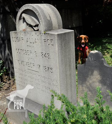
A raven marks the spot: Tavish lurks in the shadows behind the monument indicating where Edgar Allan Poe was originally interred.

As the literary master of the dark and dreary, Edgar Allan Poe (1809-1849) and his special brand of Gothic fiction tie in conveniently with the whole Halloween oeuvre. So, on this All Hallows’ Eve, allow Tavish the Intrepid Pup to take you on a virtual visit to Poe’s grave site in Maryland.

Several cities lay legitimate claims to Poe—Boston, New York, Richmond, and Philadelphia among them. Yet, it’s Baltimore where Poe not only lived with relatives in the early 1830s but also where he ultimately died under somewhat mysterious circumstances…turning what was to have been a brief stopover in October 1849 into an eternal one.

At the heart of downtown Baltimore and today encircled by the University of Maryland School of Law are the Westminster Hall Burying Grounds and Catacombs. Despite the name, these catacombs are nowhere near as creepy as the ones that figure in Poe’s own tale, The Cask of Amontillado. The burial grounds date to the late 1700s, and the 1852 church on the site—sans congregation—is now used for private event rentals.

Poe's final resting place

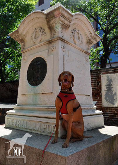
Poe’s final resting place at Westminster Hall Burying Grounds. There’s no Poe Toaster in sight…unless it’s the Intrepid Pup!?!

The cemetery is actually home to not one but two Poe memorials. Proceed to the rear of the cemetery to see Poe’s initial 1849 burial plot.  While this grave never had a marker, you can’t miss the monument eventually placed there in 1913 depicting the haunting raven immortalized in Poe’s 1845 poem by the same name. On the afternoon of our visit it was particularly hot, and Tavish managed to plunk himself down in the only piece of shade, which happened to be right behind the stone and therefore created a bit of a spooky effect (see photo, right).  As the marker’s accompanying inscription indicates, Poe was exhumed in November 1875 to be re-interred in a grave with his mother-in-law/aunt Maria Clemm (1790-1871) located near the cemetery’s entrance. A decade later, the remains of Poe’s young wife/cousin Virginia (1822-1847) were transported from New York and reunited with the others in the family plot. This marble monument (see photo, left) bears all three occupants’ names, as well as a large bas-relief of Poe’s likeness.

More than two centuries later, there’s still a morbid fascination with all things Poe, and perhaps nothing epitomizes this better than the anonymous soul (or souls?) known simply as the “Poe Toaster.” Beginning in 1949 on the anniversary of Poe’s birth—and continuing for 60 years!—a man would visit the monument in the dead of night to leave a half-full bottle of cognac and three red roses.  A no-show on what would’ve been Poe’s 201st birthday heralded the end of this curious tradition, prompting local headlines to proclaim the Poe Toaster “nevermore.”

Dogging the Details

Click to see what a "1" on the Wag-a-meter means39°17′23.25″N,  76°37′23.35″W   Find it on the Intrepid Pup Map >
Westminster Hall Burying Grounds and Catacombs, Baltimore, Maryland

Literary history meets an easy bit of urban exploration to register a “1” on the Intrepid Pup wag-a-meter for this excursion.

The nearest parking garage is a block away at the Baltimore Grand (5 North Paca Street).

Upon arrival, take care in traversing the uneven brick walkways within the cemetery, and respect the grave markers. Westminster Hall offers seasonal, guided tours, but there’s a surprising amount of information to be found on various historical plaques throughout the grounds should you prefer to do a self-guided version. Spoiler alert: Poe is not the only famous historical figure buried here! Among others, look for the grave of James McHenry (1753-1816), the namesake of Baltimore’s Fort McHenry of Star Spangled Banner fame.

There Be Dragons!

Tavish at Deal's Gap's Tail of the Dragon

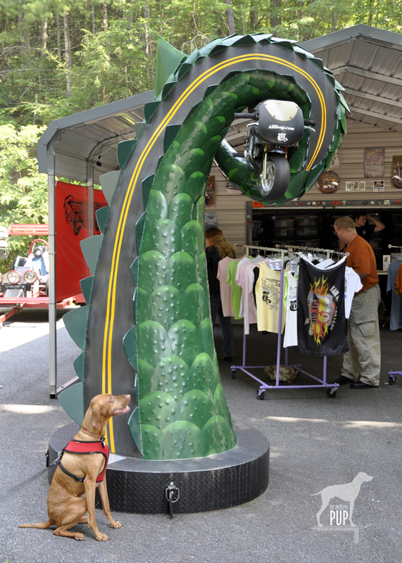
Tavish seemingly not intimidated by the Tail of the Dragon with a motorcycle in its clutch.

Tavish the Intrepid Pup‘s therapy dog vest sports several pins, many of which represent places he’s traveled. Mostly they’re conversation starters, and by far the one that attracts the greatest attention—primarily from kids—is the Day-Glo yellow one shaped like a road sign bearing the silhouette of a dragon and the words, “At the Gap there be dragons.” Here’s the backstory:

Last July, Tavish and Team Tavish were visiting friends in Tennessee who were eager to show us the Tail of the Dragon. It’s a storied stretch of Highway 129 that straddles the border of Tennessee and North Carolina. More accurately, it’s 318 curves in 11 miles with up to a 12% grade and 1800 feet in elevation. Hence the vivid and apt comparison to a jagged dragon’s tail. Were it a TV commercial, it’d have that impossibly fine print flickering across the bottom of the screen saying, “Do not attempt. Professional driver on a closed course.” Indeed, there have been vehicle performance tests done here, and for obvious reasons, the road is a magnet for motorcycle and sports car enthusiasts.

We had visions of “slaying the dragon” Easy Rider-style, with a Doggles®-wearing Intrepid Pup in a cool sidecar. The biggest problem with this plan was that neither we nor our friends own motorcycles. So, we did this trip in decidedly less hip fashion in what was probably an affront to the road itself: our friends’ 2001 Hyundai Elantra. Eat your heart out, James Dean.

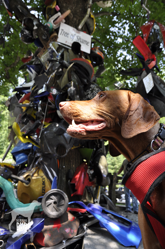
Deal's Gap Motorcycle Resort's Tree of Shame

Who says that kinetic, post-modern sculpture can only be found in chic art galleries? Deal’s Gap has a pretty good example with its “Tree of Shame.”

Our friend drove and would periodically concede to the far more intrepid bikers by easing into paved pull-offs, earning us many appreciative nods and an occasional wave. It was also blisteringly hot that day, so the Intrepid Pup was favoring the Elantra’s AC vents over lolling out the window. But even without a white-knuckled Nürburgring experience, this was still a drive we’re glad we did.

There are a handful of entrepreneurial outfits that station photographers along the Tail of the Dragon. The business model is akin to having your photo taken at an amusement park while on some giant roller coaster and then having the opportunity to purchase said photo as you exit the ride. (Editor’s note: We did go online afterwards and easily found ourselves in that day’s batch of pictures…after all, there aren’t exactly zillions of silver Elantras amid the supercars and slick Harley-Davidsons. And, as you might’ve guessed, our souvenir car shot is best left to your imagination.)

Rounding the final curves and easing down that last slope (Wheelie Hill), reward you with the gateway attraction that is Deal’s Gap. Touting its own special brand of self-proclaimed “two-lane tourism,” Deal’s Gap consists of Tail of the Dragon LLC (an outlet store and de facto visitor information center) on one side of the highway and Deal’s Gap Motorcycle Resort (with accommodations, a shop, and a 65-seat pub) on the other.

Deal's Gap statuaryThere are two standouts in this spectacle. One is the signature green “tail” pictured above. The other is the Tree of Shame  located in the motorcycle resort’s parking lot. This crowd-sourced totem is part whimsy, part rite-of-passage, and part cautionary tale. Basically it’s 20+ years of jetsam—smashed reflectors, blown tires, broken headlights, dented hubcaps, and shorn fenders—lobbed in frustration by those unlucky enough to have been “bitten by the dragon.”  The tree is always in flux as pieces get added or otherwise shift among the branches (a nearby sign warns, “CAUTION: Watch for falling parts from Tree of Shame”). It’s also a good reminder that riding the Tail of the Dragon carries an inherent risk; over the past 12 years, there’s been an average of slightly more than two deaths a year.
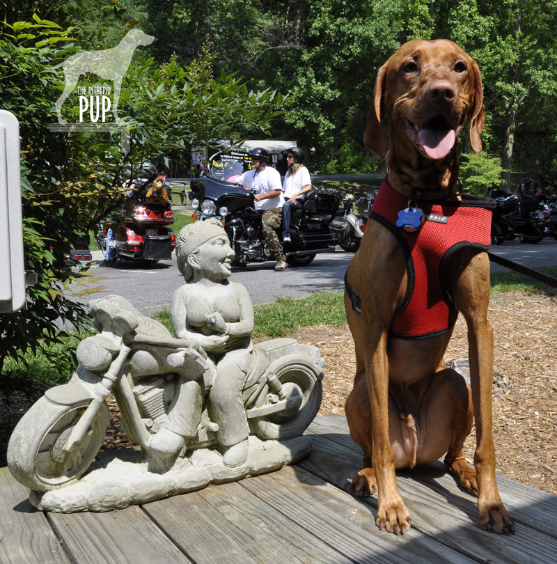
The parking lot is better than any showroom for gawking at the bikes, and it was here that Tavish made a few new friends. He plunked down in the shade by a random, concrete statue (doorstop?) of a bikini- and bandanna-clad biker and drew his fair share of affectionate pats from bikers returning to their rides. Many intended to traverse the route several times that day, and one biker nostalgically reminisced to us about his own pup that he never wanted to be away from for too long.

Maybe, just maybe, Tavish will get that ride in a sidecar yet!

Dogging the Detaihttp://tailofthedragon.com/index.htmlls

Click to see what a "1" on the Wag-a-meter means

35°27′59.77″N,  83°55′9.99″W
Highway 129
(a.k.a. Tail of the Dragon),  Tennessee/North Carolina, with a stop at Deal’s Gap

35°18′22.87″N,  84°00′46.45″W
Cherohola Skyway (Routes 143/165), North Carolina/Tennessee

This excursion rates a “1” on the Intrepid Pup wag-a-meter. It was a fun, scenic outing and, aside from the driving, was not very strenuous…particularly if you’re a dog! In all, we covered 113 miles that afternoon, but this represented three hours of actual driving time, because speed limits are just 30 mph on the Tail of the Dragon and 40 mph on the Cherohala Skyway.

Cherohala Skyway

The Cherohala Skyway is the “mile-high legend.” Tavish proves it by standing at the Santeetlah Overlook, the route’s highest elevation at 5390 feet.

We had started out just south of Knoxville, snaking southeast on the Tail of the Dragon. En route we passed the Cheoah Dam. Besides holding back the water of the Little Tennessee River, it’s also famous for being the dam from which Dr. Richard Kimble—portrayed by actor Harrison Ford—swans dives in the 1993 thriller The Fugitive. It wasn’t easy for us to pull off the road right then, so there’s no Intrepid Pup photo…you’ll just have to take our word for it. We decided to extend our drive by daisy-chaining from the Tail of the Dragon right onto the Cherohala Skyway, a 60-mile, high-elevation road running west from Robbinsville, North Carolina, to Tellico Plains, Tennessee. But be sure to top off your fuel tank at Deal’s Gap as there are no gas stations on this segment. The route takes its name from the two national forests (Cherokee and Nantahala) it transects.

We made a couple stops along the Skyway to check out some pretty amazing vistas. From the sheer elevation, it’s easy to see why much of the highway gets closed during wintry weather.  Before a passing thunderstorm hit, we were also able to stretch our legs and get in a short 0.75-mile hike with Tavish along a roadside trail with interpretive signs about railroads and timber harvesting.

Save

Journey to the Edge of Shangri-La

Catoctin Trail

That got your attention, didn’t it? OK, so while Tavish the Intrepid Pup technically didn’t stumble upon the mystical paradise described in Lost Horizon, he came pretty close to a Shangri-La. In Thurmont, Maryland, that is.

Catoctin Mountain Park, administered by the National Park Service, is some 10,000 acres of hardwood forest interspersed with recreational areas and a lot of history. Its past is interwoven with that of sawmills, whiskey stills, tanneries, charcoal production, and pig iron. In the 1930s it was shaped into the Catoctin Recreational Demonstration Area by the WPA and the Civilian Conservation Corps. Of this expanse, the Hi-Catoctin Camp for families of federal workers caught the eye of President Franklin D. Roosevelt as a viable spot for a presidential retreat. Roosevelt hadn’t been too keen on adopting his predecessor President Herbert Hoover’s retreat (Camp Rapidan) in Shenandoah, in part because its remoteness presented challenges for Roosevelt’s physical condition. But Hi-Catoctin was just an hour northwest of Washington, DC, and refreshingly cooler in the summer to boot. Roosevelt first visited Catoctin in April 1942, and the existing camp was quickly converted to a presidential retreat he dubbed “Shangri-La” after the utopia in James Hilton’s popular 1933 novel. It became a true haven for the president during World War II, and British Prime Minister Winston Churchill even came there for the Third Washington Conference in 1943. After Roosevelt’s death, President Harry Truman recognized the importance and significance of Shangri-La and preserved it through an arrangement with the National Park Service. When President Dwight D. Eisenhower came into office, he readily embraced Shangri-La but with one significant modification: he renamed it Camp David after his grandson! It’s kept that name ever since and has seen several historic moments, from visits by Leonid Brezhnev, Nikita Khrushchev, and Margaret Thatcher to the 1978 summit with Anwar Sadat and Menachem Begin culminating in the Camp David Accords. As you might suspect, Shangri-La (a.k.a. Camp David) is neither visible from any of the park roads nor open for visitation by the general public even if you do find it.

However, you have the whole rest of the park at your disposal, and with 25 miles of available hiking trails ranging from easy to strenuous, you can readily assemble an itinerary that strikes your fancy. We ended up covering about 5 miles during our visit by hiking the out-and-back Cunningham Falls Nature Trail (2.8 miles round-trip, with a nice view of the falls), the Hog Rock Nature Trail loop (1.5 miles, featuring 14 kinds of trees and nice vista of the Monocacy Valley), and the Blue Ridge Summit Trail (0.6 mile round-trip, with a rocky overlook at an elevation of 1520 ft). Just to manage expectations: at no time did Bo, President’s Obama’s Portuguese Water Dog, come bounding up to us. In fact, we were kind of surprised by how uncrowded the park was, but we chalked it up to the fact that rain in the forecast was keeping folks away. We’ll definitely be back to tackle some of the other routes!

Click to see what 2 on the Wag-A-Meter meansDogging the Details

39°39′1.54″N,  77°27′50.65″W
Catoctin Mountain Park, Thurmont, Maryland

39°37′5.79″N,  77°24′56.46″W
The Cozy’s Camp David Museum, Thurmont, Maryland
[Update: The Cozy closed in June 2014]

This excursion is a solid “2” on the Intrepid Pup’s wag-a-meter. Catoctin is a great natural setting that welcomes leashed dogs, and the hiking trails are very well marked and maintained.

Catoctin Mountain Park

Tavish on the lush and shady Cunningham Falls trail. We passed a total of six other dogs on this popular route.

Make the Park Service’s Visitor Center at Catoctin Mountain Park your first stop. There is no entrance fee for the park, although rates do apply if you’ll be availing yourself of any of the four cabin camp rental sites. The ranger can outfit you with a trail map and recommend what hikes will best suit your group and the time you have available. Particularly neat is the park’s current initiative, the “Healthy Park | Healthy People Challenge.” You’re given a pamphlet listing a combination of 13 interpretive trails and scenic overlooks in the park. With each destination attained, you have a ranger record it on your sheet. Make it to all 13 spots and you’ll earn a special Catoctin Mountain Park carabiner!

The Visitor Center contains restroom facilities, outdoor trash receptacles, a small museum covering the cultural heritage and natural history of the region, and a park bookstore/gift shop that even carries collapsible water bowls and pet bandanas stamped “National Bark Ranger” (um, yeah, we bought one).

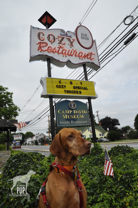
After truly enjoying hiking in the park, our next stop was the historic Cozy in downtown Thurmont. Established in 1929, Cozy is Maryland’s oldest restaurant still run by its founding family. That in and of itself makes the Cozy noteworthy in this day and age, but it’s the Cozy’s other claim to fame that had Team Tavish intrigued. In addition to the Cozy Country Inn and Cozy Village Shops, the Cozy complex is home to the nation’s “only museum of Camp David history.” You come upon the outdoor painted plaque that says that Mamie Eisenhower and Babe Ruth are among the notables who’ve dined here, open the door to the family-style restaurant,  and boom:  there’s the Camp David Museum.

Camp David MuseumA modest-sized room off the main dining area serves as the gallery chock full of photographs and memorabilia highlighting the Cozy’s Camp David connections to 13 presidential administrations and counting. There’s a perfect photo opp beneath a rustic “Camp David” sign, but sorry, no dogs allowed inside.

For security reasons Camp David doesn’t show up on the Park Service trail maps, but area residents are accustomed to Camp David hubbub and seem happy enough to demystify things for you. One nice lady we met (alas, didn’t catch a name) recalled how broadcast journalist “Barbara Wawa” would hike up her skirt and vault a fence so she’d be the first out to the helicopters that used the parking lot of a local car dealership as a  landing pad. Time was that President Franklin D. Roosevelt’s Secret Service agents stayed at the Cozy. JFK’s cabinet members often dined there, and the Cozy was the lodging of choice for guests attending President George H. W. Bush’s daughter Doro’s wedding at Camp David in 1992. And then there were tales of television reporters who had their favorite yards or trees downtown that they’d always use as backdrops for reporting “live from Camp David”…even though all the locals watching the evening news knew better.

Yet, despite the G8 Summit being held at Camp David just two months ago (May 2012), Team Tavish detected a hint of wistfulness in our new-found Thurmont-er friend. “It’s not quite like it used to be,” she said. “Now all those world leaders just Skype and email each other, you know. And President Obama really seems to be more of a beach kind of guy, so I don’t think he gets up here as much as some of the other presidents did.”

Everything in the Cozy’s various displays has been donated over the years by visiting White House staffers, dignitaries, and members of a generous press corps. It seems that the bus tours that stop for repast at the Cozy are a pretty discerning bunch, and it apparently hasn’t gone unnoticed that the Obama section of the Camp David Museum is a little sparse. Don’t blame the Cozy, however, as they know their audience and aim to please. They’ve submitted requests for items through “official channels” and have even improvised by adding a few generic images of the First Family. But at the end of the day, Team Tavish had to concur with the assessment of our casual acquaintance: “Photos downloaded from the internet somehow just don’t cut it.”

So, if someone at the White House happens to be reading this (and we know hope you are!), the Intrepid Pup encourages you to  “throw a bone” to the Cozy’s Camp David Museum in the way of some Obama swag and a few recent photos of the president at Camp David. Who knows? It might just translate to some key votes from Thurmont-ers and Cozy-philes in the November elections.