Earlier this year Team Tavish wrote about the first Great Maine Outdoor Weekend (GMOW), a new bi-annual event that promotes physical activity and encourages folks to revel in all that’s great about Maine’s natural resources. September 28-30, 2012, marked the second GMOW, and with it, Tavish the Intrepid Pup promised to offer “Part II,” revealing three more stunning destinations in Vacationland. He enjoyed frequenting these places in the 5½ years he lived there, so he’s pretty confident that you and your dog will enjoy them too. So, without further ado…
Dogging the Details
Though in three separate regions of Maine, the excursions described below all rank “2” on the Wag-a-meter as being active, outdoor adventures requiring a little bit of planning. As always, be sure to bring along water for your dog, a snack, and some doggie bags.
MAINE LAKES AND MOUNTAINS
44°56′08.58″ N, 70°32′13.24″ W
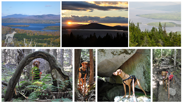
Rangeley Lakes, MaineRangeley. The region is virtually synonymous with northern New England, and place names like Mooselookmeguntic and Height of Land simply reinforce its remote and wild allure. It’s the backdrop for Maine’s logging history. The playground for countless generations of sportsmen. The muse of the legendary Carrie Stevens (1882-1970) and her streamer fly. The setting for author Louise Dickinson Rich’s (1903-1991) best sellers, and the thirty-year summer retreat of iconic photographer William Wegman and his famous dogs.
To enter Rangeley is to embrace Maine’s great outdoors. Team Tavish and the Intrepid Pup have twice stayed at Town & Lake Motel and Cottages; once in late May and again in October. Located on the shore of Rangeley Lake, next to where the sea planes dock, the motel is pet-friendly and a more than adequate home base from which to explore the area. In-room reading is a binder chock full of historical ice out dates, leaving no mistake that this is definitely a place for hard core snowmobilers and ice fishermen.
While Rangeley rightly promotes itself as a four-season wonderland, summer and fall are really the best times for visiting with your dog. Come prepared for great hiking, amazing scenery…and the near certainty of seeing moose. But be equally prepared for black flies, cool nights, and rapidly changeable weather. Tavish made good use of his Ruffwear™ pack to carry extra food and water for the day. Wearing blaze orange was a must during our autumn hikes as hunting season was in full effect. (Click here to see some of his gear).
The Rangeley Lakes National Scenic Byway is a 35-mile ribbon incorporating sections of Routes 16 and 17. It’s also the access corridor to a number of trail heads of varying lengths and degrees of difficulty. Tavish-approved highlights include:
- The short 0.5 mile trail at the 2000-foot Cascade Stream Gorge, with views of 16-foot waterfalls and deep pools.
- The roadside turnoff at Smalls Falls, with a walkway to see the 54-foot falls.
- A 1.75 mile trail to the summit of Bald Mountain (2443 feet), with its 30-foot lookout tower.
- The Appalachian Trail, with a 1.4 mile section to the impressive Piazza Rock.
- Miles of trails on the 4120-foot Saddleback Mountain. This ski resort permits hikers on base area trails and ski runs during the off season. The chair lifts aren’t operational in the summer, but parts of the main lodge remain open. With wide open spaces, lots of birds to watch, and plenty of evidence of deer and moose, this was probably Tavish’s favorite to explore.
GREATER PORTLAND AND CASCO BAY
43°49′14.47″ N, 70°04′54.05″ W
Wolfe’s Neck Woods State Park, Freeport, MaineEven if you’re otherwise unfamiliar with Maine, you’ve likely heard of Freeport, thanks to it being the venerated home of outdoor outfitter L.L. Bean. The flagship store is so touted as a Maine destination that you pretty much have to stop by. While you’re there, sneak a peek at the store’s doors. They’re notable for what’s missing, namely locks. Since the facility is open 24 hours a day/365 days a year, there’s simply no need for them. That’s what we call a good dose of Yankee practicality. Seriously, check it out…and be sure to snap a photo out front with the 16-foot replica of the hunting boot that launched the company and secured Leon Leonwood Bean’s legacy in the annals of retail history. While your dog can’t accompany you in the store, there’s plenty of dog gear (hunting and otherwise) to be found inside. And you and your dog can always chill in Discovery Park; in the middle of the L.L. Bean retail campus, this compact greenspace doubles as an expo area during Bean’s product demo days and also has a stage on which the company presents its free summer concert series.
But if you can extricate yourself from the constellation of outlet stores downtown, you’ll find that Freeport “beyond the Boot” has a lot to offer in the way of natural splendor. Just a 5-minute drive and you’re quickly away from the 3 million visitors who flock to town each year. Take Bow Street to Flying Point Road, and make Wolfe’s Neck Woods State Park your destination. L.L. Bean’s Paddling Center is just an inlet away from this easily accessible state park.
While you won’t likely get short of breath walking at Wolfe’s Neck, the views will most certainly take your breath away. Within steps of leaving the parking lot picnic area, the Casco Bay Trail slopes gently to where emerald conifer forest meets azure sea and sky. The stolid outcrops that dot the bay are whimsically called the “Calendar Islands,” because surely there are 365…one for every day of the year! The closest is Googins Island, an osprey sanctuary, and every time we’ve visited during the summer we’ve seen nesting osprey. The trail skirts a pebbly coastline before linking up to the Harraseckett and Hemlock Ridge trails to form about a mile-long loop returning you to the parking lot. Do note that there are no receptacles along the trail, so bag any waste for disposal back at the picnic area.
MAINE BEACHES
43°14′42.43″ N, 70°35′31.14″ W
Marginal Way, Ogunquit, Maine43°13′24.49″N, 70°41′30.11″W
Mount Agamenticus,York, MaineNot far after crossing Maine’s southernmost border you reach Ogunquit, a town whose apt Chamber-of-Commerce-tagline is “Beautiful Place by the Sea.” Park anywhere you can. Be forewarned that this is a particularly challenging task during the summer months, though a good place to try first is the pay lot just down Shore Road on Cottage Street. If you’re successful in finding a spot in the upper part of town (near the intersection of Route 1 and Shore Road), walk along Shore Road until you come to the Sparhawk Oceanfront Resort; a narrow walkway bordered by tennis courts and lush gardens leads to one of the best coastal trails you’ll ever come across: the Marginal Way.
Dogs are not allowed on the Marginal Way between April 1 and September 30 but are welcome on-leash from October 1 through March 31 (and you can take in the October “HarvestFest” and the December “Christmas by the Sea” activities then, too). The Marginal Way traverses Anchorage by the Sea Resort’s sprawling oceanfront before gaining elevation and hugging the rocky coastline for approximately 1 mile. The 39 benches dotting the paved path offer ample opportunity for quiet contemplation and gazing upon the oft-painted vistas of Ogunquit Beach, the Atlantic Ocean, and a small lighthouse. Marginal Way’s terminus is at Oarweed Cove; a narrow spit of land separates it from the compact yet equally picturesque Perkins Cove. Fishing charters depart from the wharf, and visitors flock to photograph the harbor, browse the cluster of art galleries and boutiques, and enjoy lobster rolls and chowder. While you can always retrace your steps—Marginal Way never gets old!—an alternate way back is to walk along Perkins Cove Road and then Shore Road, passing numerous shops en route.
A nearby point of interest is Mount Agamenticus, just 6.5 miles southwest of downtown Ogunquit, in York. Take Route 1 south a few miles, make a right onto Agamenticus Road, and another right onto Mountain Way. Just when you start to think you’re lost on this curvy back road, you’ll see signs for the Mount Agamenticus summit. Rising only about 700 feet, Agamenticus is clearly no Everest, but its proximity to sea level makes it a prominent fixture on the horizon. The surrounding 10,000 acres are managed as a conservation region, thus preserving vernal pools, a superb vantage point for watching migratory hawks, a unique coastal ecological habitat, and a good bit of history. The first radar tower in the nation was placed atop Agamenticus in the 1940s, and the expansive view of the southern Maine coast made it strategic for spotting submarines and warships during WWII. In later years, wildfires became a greater threat than enemy vessels; the radar tower was supplanted by a fire tower still actively manned today. Agamenticus even enjoyed a brief and more benign stint (1964-73) as a ski resort. The summit lodge remains, and many of today’s multi-use trails (hiking, mountain biking, snowshoeing/cross-country skiing) were once ski runs.
Intrepid Pup loves the ruggedness, summit view, and relative solitude. Like giant calluses on the landscape, the smooth outcroppings of bedrock on so many of the former ski slopes can prove slick for the two-footed (particularly during spring run-off and mud season), but scrambling over the terrain is what Tavish most enjoys about a visit to Agamenticus. Choose from among three loop trails that vary in length from 2 to 3.2 miles. Dogs must remain leashed, and all waste must be packed out, because there are no trash bins onsite.




 If you’ve always associated Maine with craggy shorelines, there are plenty. But you might be surprised to learn that beautiful sandy beaches can be found in coastal towns throughout southern Maine. One favorite is Kennebunk Beach. At low tide, this crescent-shaped swath of sand extends out about a hundred yards before receding into the Atlantic Ocean. Then, if you could even see this far, the next land you’d spot would be Portugal. Seriously. The surrounding communities, collectively known as the Kennebunks, are tourist magnets (particularly in the summer and fall), but Kennebunk Beach holds a year-round allure even after temperatures for swimming and sun-bathing are but distant memories. The sidewalk follows the shoreline and is great for dog-walking, complete with several waste receptacles and doggie-bag dispensers. In fact, this same scenic route along the seawall is used by the area’s Animal Welfare Society for its insanely popular (and fun) annual “Strut Your Mutt” fundraiser.
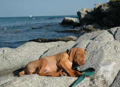 Team Tavish dug back into the Intrepid Pup archives for this pic of an approximately 11-week-old Tavish on one of his very first trips to what would become a frequent destination: Peaks Island. Of the several hundred island communities that dot Casco Bay, Peaks is the most populous with ~1,100 year-round residents, though that number swells to 4,000+ during the summer months. Peaks is actually part of the City of Portland, but its history has been punctuated by various—and as yet, unsuccessful—secessionist movements. It’s accessible via a 15-minute ride from downtown Portland on the Casco Bay Lines
  Camden
 Yonder’s




 Just in time for Presidents’ Day is this week’s
  to U.S. president Gerald Ford from Ford’s daughter and the White House photographer.
